Serving as a Panelist for the Presidential Candidate Debate

I started the year of 2024 with a big step, at least for me. I was appointed by the Indonesian General Election Commision (KPU) as a panelist for the 2024 Presidential Candidate Debate. It was the third round with a topic around defence, security, international relations, geopolitics, diplomacy. It seems that my focus of research on maritime boundaries has been the reason of me being picked.

I saw, the assignment as a panellist is an accumulation of my two-decade study on geospatial aspects of the law of the sea, particularly maritime boundary issues. In May 2003, I was involved in a project of border demarcation between Indonesia and Timor Leste. The project brought me to Atambua in East Nusa Tenggara, Indonesia to conduct Global Positioning System (GPS) campaign. It was an eye-opening experience, where I started to understand the boundary making process and how it really is a multi-disciplinary issue.

I never saw that the small step I took twenty years ago would bring me to the national stage as a presidential candidate debate panelist. To be frank, I am so grateful and also proud. To be able to introduce geospatial issues in a presidential debate, for me personally, is an achievement. I really hope that the moment serve as a starting point of more positive roles in the future.

Toleransi Berseri di Ujung Negeri

UGM mewajibkan mahasiswa S1 dan D4 untuk mengikuti Kuliah Kerja Nyata (KKN) dan cukup banyak dari mereka yang memilih untuk ber-KKN di pelosok negeri, jauh dari Kampus UGM di Yogyakarta. Tahun ini saya mendapat kepercayaan mendampingi sekelompok mahasiswa untuk ber-KKN di Desa Dalum, Kecamatan Salibabu, Kabupaten Talaud, Sulawesi Utara. Secara singkat, kami biasa menyebutnya KKN Talaud.

Talaud adalah kabupaten paling utara di Indonesia dan sangat banyak orang Indonesia yang bahkan tidak mengetahuinya sama sekali. Setiap kali saya bercerita tentang Talaud, saya harus mengutip lagu iklan Indomie “dari Sabang sampai Merauke, dari Timor sampai ke Talaud”. Menariknya, tidak sedikit yang kemudian heran dan baru sadar bahwa ada kata Talaud dalam lagu itu. Rupanya sangat banyak yang mendengar “dari Sabang sampai Merauke, dari Timor sampai Kota Laut”. Tentu saja maknanya berbeda dan hilang satu titik penting di negeri ini: Talaud, kabupaten paling utara negeri.

Continue reading “Toleransi Berseri di Ujung Negeri”

Settling Maritime Borders A Tough Job

Opinion, The Jakarta Post, 24 July 2017

In an official visit to Nunukan, East Kalimantan, on June 13, 2017, Ambassador Eddy Pratomo, the Special Envoy of the President for the Determination of Indonesia-Malaysia Maritime Boundaries, informed the progress of his assignment. He clearly noted that the two countries are now working hard toward the definition of fence at sea between them and some progress have been made.

Continue reading “Settling Maritime Borders A Tough Job”

Diplomasi Kartografis di Laut Natuna Utara

Opini Kompas, 24 Juli 2017

Pemerintah Indonesia, melalui Kemenko Maritim telah mengeluarkan Peta Negara Kesatuan Republik Indonesia (NKRI) terbaru. Indonesia memang secara berkala mengeluarkan Peta NKRI. Yang istimewa dari Peta NKRI 2017 ini adalah adanya usulan penamaan ruang laut yang tadinya dikenal sebagai bagian dari Laut China Selatan (LCS), menjadi Laut Natuna Utara (LNU). Indonesia rupanya menggunakan kartografi sebagai ilmu dan seni pembuatan peta sebagai alat diplomasi.

Continue reading “Diplomasi Kartografis di Laut Natuna Utara”

ICST: The Roles of Oil Concession Definition in Maritime Boundary Delimitation

I was invited to as one of the keynote speaker at the Geomaritime Symposium at the International Conference on Science and Technology (ICST) organised by Universitas Gadjah Mada. I delivered a paper on 12 July 2017 and share a stage with my two colleagues, Gede Karang from Udayana University and Mas Aji from a university in Malaysia. Here is my abstract:

The Roles of Oil Concession Definition in Maritime Boundary Delimitation:
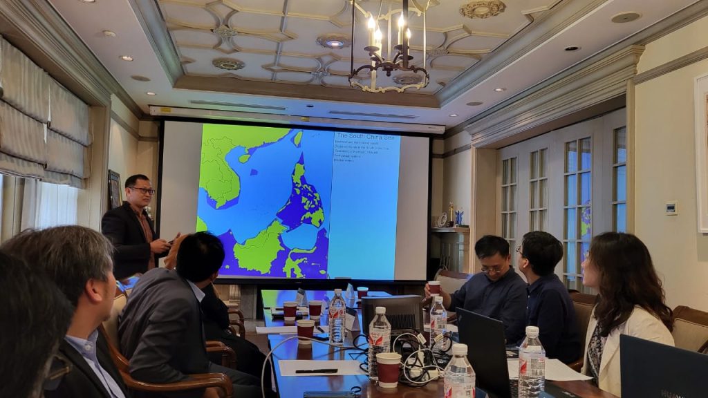
A Critical Review on the Case of the Sulawesi Sea and the South China Sea

I Made Andi Arsana
madeandi@ugm.ac.id

Department of Geodetic Engineering, Faculty of Engineering
Universitas Gadjah Mada, Indonesia

ABSTRACT

In the absence of agreed maritime boundaries, States usually have their unilaterally claimed boundary lines. In many cases, these lines represent the most forward possible line such States would want to he the final boundary lines. Thus, such lines are also known as forward positions, which are usually used by coastal States as their initial position in negotiating their maritime boundaries. In the case of Indonesia’s maritime boundaries, for example, these forward positions have been depicted clearly on its official map so they become obvious to its neighbours.

In the Sulawesi Sea, where maritime boundaries between Indonesia and Malaysia are pending, both States, using oil concession definition, have proposed their maritime claims defined by their forward positions. Indonesia, on one side, utilises oil concession it defined since the 1960s in defining its forward position. Malaysia, on the other hand, started to define its forward positions and then define oil concessions within those forward positions. The utilisation of oil concession definition to represent maritime claims has also been the case in the South China Sea as demonstrated by, for example, China and Vietnam.

This research presentation analyses the roles of oil concession definitions in defining forward position and how they may affect the delimitation of maritime boundaries between coastal States. The cases in the Sulawesi Sea and the South China Sea are investigated with reference to relevant cases in different parts of the world. Findings and conclusions are then presented.

Here is the cover of my presentation:

Communities Play a Key Role in Saving the Oceans

I Made Andi Arsana
New York City

Headline | The Jakarta Post | 13 June 2017

I was lucky enough to attend the celebration of World Oceans Day (WOD) 2017 at the United Nations Headquarters in New York. For the first time, WOD was celebrated as the main event of the UN General Assembly. The United Nations’ Division for Ocean Affairs and the Law of the Sea (DOALOS) managed to bring the celebration of WOD to the next level. Maritime Affairs and Fisheries Minister Susi Pudjiastuti was also at the event, accompanied by the Indonesian ambassador to the UN.

Continue reading “Communities Play a Key Role in Saving the Oceans”

A New Map of the South China Sea

The long-standing dispute in the South China Sea involving a number of countries in the region has now come to new stage. The unprecedented step taken by the Philippines to bring the case to the Arbitral Tribunal (administered by Permanent Court of Arbitration, PCA) eventually has brought results that some people might not even thought about before. The decision made by the Tribunal on 12 July 2016 was considered by some as a ‘major victory’ for the Philippines since it rejects most of China’s claim. The year of 2016 is a changing year for the South China Sea.

Continue reading “A New Map of the South China Sea”

Apa Kabar Poros Maritim Dunia?

Hampir tiga tahun berlalu sejak kita diperkenalkan dengan sebuah istilah “Poros Maritim Dunia” (PMD), saatnya menanyakan kabarnya kini. Menariknya, setelah hampir tiga tahun, masih cukup banyak peneliti dan pembelajar kelautan yang gamang ketika menjelaskan makna PMD. Bisa jadi memang konsep dan kebijakannya sendiri yang masih perlu penajaman atau para peneliti ini yang kurang perhatian.

Ada dua hal penting dari cita-cita Indonesia untuk menjadi Poros Maritim Dunia (PMD). Pertama, keniscayaan Indonesia sebagai negara kepulauan yang punya laut luas harus dimanfaatkan untuk kesejahteraan rakyat. Kedua, Indonesia hendak menjadi acuan bagi dunia tentang isu kelautan dan kemaritiman. Sebagai negara besar yang lautnya luas, Indonesia ingin memainkan peran penting dalam sektor kelautan dan menjadi kiblat bagi dunia. Hal ini yang sering diungkapkan oleh pihak-pihak yang turut menggagas konsep PMD.

Continue reading “Apa Kabar Poros Maritim Dunia?”

Maritime Boundaries and International Business

When I stared learning about maritime boundary issues, back in 2004, I did not quite expect that the expertise will bring em to meet a lot of people from different disciplines. While interacting with people from legal, social and political backgrounds has now become a regular thing, to be invited in a forum of international business is a certainly quite unexpected.

For the first time I was invited to talk about the relationship between maritime boundary issues and international business by the State Polytechnic of Bali (PNB). In the seminar I spoke with two other speakers and specifically discuss the impact of pending maritime boundaries to international business. Maritime security and regional safety were among other things that I discussed with audiences from different background.  I has always been fun to discuss with people with educational background that is completely different from mine. To me, the discussion was a perspective-enriching. Here is a video taken by Bali TV and was aired the night after the seminar. Enjoy!